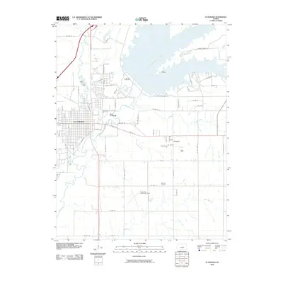
2010 Map of El Dorado
USGS Topo · Published 2010About this map
El Dorado Lake dominates the northeastern landscape of this quadrangle, its expansive waters held back by the El Dorado Lake Dam. The city of El Dorado spreads west of the Walnut River, showing a dense grid of streets that transition into the smaller neighborhoods of East El Dorado. To the south and east, the terrain opens into agricultural lands and aviation hubs like the El Dorado Municipal Airport and Patty Field.
Find a feature on this map
69 named features on this map. Tap any name to fly to it.
Don’t see what you’re looking for? This feature index may not catch every label — zoom into the map to look around manually.
Map Details
Editions of this 2010 El Dorado Map
This is the sole edition of this map. No revisions or reprints were ever made.
Other maps of this area

1888 · Eldorado
USGS Topo · 1:125,000

1955 · Wichita
USGS Topo · 1:250,000

1958 · Wichita
USGS Topo · 1:250,000

1961 · Augusta
USGS Topo · 1:24,000

1961 · Pontiac
USGS Topo · 1:24,000

1961 · De Graff
USGS Topo · 1:24,000

1961 · El Dorado NW
USGS Topo · 1:24,000

1961 · El Dorado
USGS Topo · 1:24,000
1961 · Rosalia NW
USGS Topo · 1:24,000
1961 · El Dorado SW
USGS Topo · 1:24,000