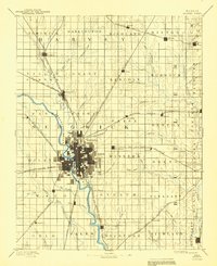
1958 Map of Wichita
USGS Topo · Published 1958About this map
Wichita serves as the industrial and aviation hub of South Central Kansas in the late 1950s, surrounded by a landscape defined by the Arkansas River drainage and a burgeoning energy sector. The map documents the city's significant aerospace footprint through Cessna Aircraft Company, Beech Aircraft Company, and the strategic presence of McConnell Air Force Base. Educational institutions like Wichita University and Friends University anchor the urban core, while the outlying regions are punctuated by critical petroleum developments including the El Dorado Oil Field and Augusta Oil Field.
Find a feature on this map
178 named features on this map. Tap any name to fly to it.
Don’t see what you’re looking for? This feature index may not catch every label — zoom into the map to look around manually.
Map Details
Editions of this 1958 Wichita Map
This is the sole edition of this map. No revisions or reprints were ever made.
Historical Maps of Wichita Through Time
6 maps found