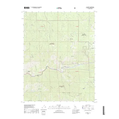
2018 Map of El Portal
USGS Topo · Published 2018About this map
The Merced River carves a central corridor through this section of the Sierra Nevada, serving as the primary artery for the communities of El Portal and Rancheria Flat. The landscape is defined by the convergence of three major public lands: Yosemite National Park, Stanislaus National Forest, and Sierra National Forest. This intersection highlights the complex land management of the region, where the steep canyon walls of Ned Gulch and Cranberry Gulch meet prominent elevations like Trumbull Peak.
Find a feature on this map
68 named features on this map. Tap any name to fly to it.
Don’t see what you’re looking for? This feature index may not catch every label — zoom into the map to look around manually.
Map Details
Editions of this 2018 El Portal Map
This is the sole edition of this map. No revisions or reprints were ever made.
Other maps of this area

1897 · Yosemite
USGS Topo · 1:125,000

1900 · Yosemite
USGS Topo · 1:125,000

1903 · Yosemite
USGS Topo · 1:125,000

1909 · Yosemite
USGS Topo · 1:125,000

1947 · El Portal
USGS Topo · 1:24,000

1947 · Mariposa
USGS Topo · 1:250,000

1947 · El Portal
USGS Topo · 1:62,500

1947 · Buckingham Mtn
USGS Topo · 1:24,000
1947 · Feliciana Mtn.
USGS Topo · 1:24,000
1947 · Kinsley
USGS Topo · 1:24,000