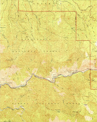
1949 Map of El Portal
USGS Topo · Published 1949About this map
The Merced River canyon serves as the central artery for this late 1940s survey, marking the primary gateway into Yosemite National Park. The settlement of El Portal sits at the river's bend, flanked by Rancheria Flat and the Indian Flat Guard Sta. This era captures the transition of access via the Yosemite All-Year Highway, which follows the steep canyon floor below peaks such as Trumbull Peak and Eagle Peak.
Find a feature on this map
62 named features on this map. Tap any name to fly to it.
Don’t see what you’re looking for? This feature index may not catch every label — zoom into the map to look around manually.
Map Details
Editions of this 1949 El Portal Map
2 editions found
Other maps of this area

1897 · Yosemite
USGS Topo · 1:125,000

1900 · Yosemite
USGS Topo · 1:125,000

1903 · Yosemite
USGS Topo · 1:125,000

1909 · Yosemite
USGS Topo · 1:125,000

1947 · El Portal
USGS Topo · 1:24,000

1947 · Mariposa
USGS Topo · 1:250,000

1947 · El Portal
USGS Topo · 1:62,500

1947 · Buckingham Mtn
USGS Topo · 1:24,000
1947 · Feliciana Mtn.
USGS Topo · 1:24,000
1947 · Kinsley
USGS Topo · 1:24,000