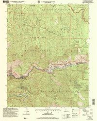
2004 Map of El Portal
USGS Topo · Published 2007About this map
Merced River canyons and steep montane terrain define this Mariposa County landscape during the early 21st century. The map centers on the El Portal gateway, showing the transition from the Stanislaus National Forest and Sierra National Forest into the Yosemite National Park boundary. Several distinct settlements and historic sites are visible along the river corridor, including Rancheria Flat, Incline, and Clearing House. Higher elevations reveal notable landmarks such as the Merced Grove Big Trees in the northwest and Trumbull Peak to the west.
Find a feature on this map
44 named features on this map. Tap any name to fly to it.
Don’t see what you’re looking for? This feature index may not catch every label — zoom into the map to look around manually.
Map Details
Editions of this 2004 El Portal Map
This is the sole edition of this map. No revisions or reprints were ever made.
Other maps of this area

1897 · Yosemite
USGS Topo · 1:125,000

1900 · Yosemite
USGS Topo · 1:125,000

1903 · Yosemite
USGS Topo · 1:125,000

1909 · Yosemite
USGS Topo · 1:125,000

1947 · El Portal
USGS Topo · 1:24,000

1947 · Mariposa
USGS Topo · 1:250,000

1947 · El Portal
USGS Topo · 1:62,500

1947 · Buckingham Mtn
USGS Topo · 1:24,000
1947 · Feliciana Mtn.
USGS Topo · 1:24,000
1947 · Kinsley
USGS Topo · 1:24,000