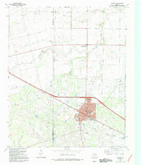
1918 Map of Electra
USGS Topo · Published 1918About this map
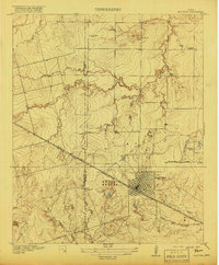
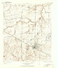
Electra stands as a burgeoning hub for North Texas agriculture and transport just before the end of the first World War. The town is the focal point of a radial road network, with primary routes including the Vernon Fort Worth Road and the Denver City Road connecting it to regional centers. The map reveals a structured rural landscape defined by the Wilbarger Co Wichita Co boundary and a series of community institutions that suggest a densely settled farming population. Local education is anchored by the County Line School, Enterprise School, and Red River School, while the Mt Carmel Church serves as a spiritual landmark. The drainage of the area is characterized by the winding paths of China Creek and Adams Creek, which cut through the undulating terrain south toward the South Fork Buffalo Creek.
Find a feature on this map
18 named features on this map. Tap any name to fly to it.
Don’t see what you’re looking for? This feature index may not catch every label — zoom into the map to look around manually.
Map Details
Editions of this 1918 Electra Map
This is the sole edition of this map. No revisions or reprints were ever made.
Historical Maps of Electra Through Time
10 maps found
1916 Electra
Wichita County, TX
1918 Electra
Wichita County, TX
1958 Electra
Wichita County, TX
1972 Electra
Wichita County, TX
1991 Electra
Wichita County, TX
2010 Electra
Wichita County, TX
2012 Electra
Wichita County, TX
2016 Electra
Wichita County, TX
2019 Electra
Wichita County, TX
2022 Electra
Wichita County, TX