
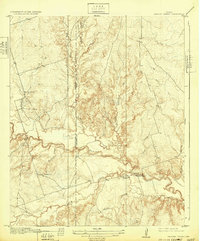
1920 Map of Beaver Creek
USGS Topo · Published 1920About this map
Beaver Creek carves a winding path through the north Texas prairie, defining the physical and social geography of this 1910s landscape. Topography engineers R.W. Burchard and R.R. Monbeck documented a rural territory where community life centered around small, scattered institutions. The eastern portion of the map is anchored by Marvin Chapel and the nearby Beaver Creek School, while Ronda School serves the northwest near the confluence of Sunflower Creek.
Find a feature on this map
16 named features on this map. Tap any name to fly to it.
Don’t see what you’re looking for? This feature index may not catch every label — zoom into the map to look around manually.
Map Details
Editions of this 1920 Beaver Creek Map
2 editions found
Other maps of this area

1915 · Barwise School
USGS Topo · 1:24,000

1916 · Electra
USGS Topo · 1:24,000

1916 · Fowlkes
USGS Topo · 1:24,000

1917 · Beaver Creek
USGS Topo · 1:24,000

1918 · Electra
USGS Topo · 1:31,680

1918 · Barwise School
USGS Topo · 1:31,680

1919 · Fowlkes
USGS Topo · 1:31,680

1954 · Wichita Falls
USGS Topo · 1:250,000

1955 · Lawton
USGS Topo · 1:250,000

1958 · Wichita Falls
USGS Topo · 1:250,000