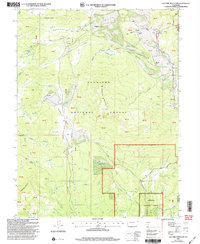
2001 Map of Electric Mountain
USGS Topo · Published 2004About this map
Electric Mountain stands as a central landmark in this high-elevation landscape within the Gunnison National Forest. Mapping in the early 2000s reveals a terrain defined by a complex network of water management and cattle ranching, marked by historic outposts like the West Muddy Ranger Sta. The topography is etched with numerous irrigation projects, including the Norell Ditch and the Overland Ditch, which redirect water from alpine drainages like West Muddy Creek and Beaver Creek to support the local agricultural economy. Private holdings such as the Norells Bell Ranch and Columbine Ranch are situated among distinct geological features like Chimney Rocks and the Lombard Slides. The presence of several Gaging Sta locations along the creek beds highlights the ongoing importance of hydrological monitoring in this western drainage basin.
Find a feature on this map
89 named features on this map. Tap any name to fly to it.
Don’t see what you’re looking for? This feature index may not catch every label — zoom into the map to look around manually.
Map Details
Editions of this 2001 Electric Mountain Map
This is the sole edition of this map. No revisions or reprints were ever made.
Other maps of this area

1938 · Mt. Gunnison
USGS Topo · 1:48,000

1945 · Mount Gunnison
USGS Topo · 1:62,500

1956 · Montrose
USGS Topo · 1:250,000

1957 · Leadville
USGS Topo · 1:250,000

1959 · Leadville
USGS Topo · 1:250,000

1959 · Montrose
USGS Topo · 1:250,000

1960 · Leadville
USGS Topo · 1:250,000

1960 · Montrose
USGS Topo · 1:250,000

1961 · Electric Mountain
USGS Topo · 1:24,000

1961 · Porter Mountain
USGS Topo · 1:24,000