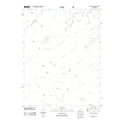
2011 Map of Electric Peak
USGS Topo · Published 2011About this map
Sangre de Cristo Mine and the Rito Alta Mine stand as significant markers of the extractive industry in this high-elevation landscape. The terrain is defined by a series of dramatic basins and peaks, where the remnants of mining operations like the Big Horn Mine and Cloverdale Mine are found within the Cloverdale Basin. These industrial sites are interspersed with high-country water bodies, including the Brush Creek Lakes, Teasup Lake, and the aptly named Rainbow Lake in the north. The drainage patterns of North Brush Creek and Cotton Creek illustrate the complex watershed of the Sangre de Cristo range. Notable landmarks such as Electric Peak, Mount Owen, and Spread Eagle Peak provide geographic anchors for researchers tracing historical mining claims and alpine land use in this part of Saguache County.
Find a feature on this map
57 named features on this map. Tap any name to fly to it.
Don’t see what you’re looking for? This feature index may not catch every label — zoom into the map to look around manually.
Map Details
Editions of this 2011 Electric Peak Map
This is the sole edition of this map. No revisions or reprints were ever made.
Other maps of this area

1950 · Valley View Hot Springs
USGS Topo · 1:24,000

1954 · Pueblo
USGS Topo · 1:250,000

1957 · Pueblo
USGS Topo · 1:250,000

1958 · Pueblo
USGS Topo · 1:250,000

1958 · Beckwith Mountain
USGS Topo · 1:24,000

1959 · Electric Peak
USGS Topo · 1:62,500

1959 · Howard
USGS Topo · 1:62,500
1959 · Horn Peak
USGS Topo · 1:24,000

1959 · Cotopaxi
USGS Topo · 1:62,500

1962 · Pueblo
USGS Topo · 1:250,000