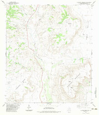
1983 Map of Elephant Mountain
USGS Topo · Published 1983About this map
Elephant Mountain dominates this Brewster County landscape, rising sharply above the surrounding high desert terrain. The drainage of Calamity Creek serves as a central artery through the quadrangle, flanked by the massive elevated plateaus of Nevill Mesa and Crossen Mesa. This 1980s-era survey reveals a network of jeep trails and isolated ranching infrastructure, such as the Corral and various Springs, that define the remote character of the Trans-Pecos. Along the primary road, a Roadside Park and several Bench Marks, including BM 4323, offer fixed points for travelers moving through the wide-open expanse between the mesas. Water sources like Sheep Creek and Ash Creek highlight the vital, sparse hydrology that dictated land use in this arid region, where high-elevation landmarks like the Radio Tower and Nevil peak provide essential orientation.
Find a feature on this map
24 named features on this map. Tap any name to fly to it.
Don’t see what you’re looking for? This feature index may not catch every label — zoom into the map to look around manually.
Map Details
Editions of this 1983 Elephant Mountain Map
This is the sole edition of this map. No revisions or reprints were ever made.
Other maps of this area

1895 · Alpine
USGS Topo · 1:125,000

1917 · Santiago Peak
USGS Topo · 1:62,500

1917 · Buck Hill
USGS Topo · 1:62,500

1918 · Bone Spring
USGS Topo · 1:125,000

1918 · Buck Hill
USGS Topo · 1:62,500

1918 · Santiago Peak
USGS Topo · 1:62,500

1920 · Monument Spring
USGS Topo · 1:62,500

1921 · Monument Spring
USGS Topo · 1:62,500

1925 · Buck Hill
USGS Topo · 1:62,500
1938 · Santiago Peak
USGS Topo · 1:62,500