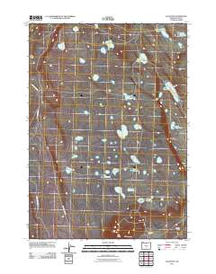
2011 Map of Elk Butte
USGS Topo · Published 2011About this map
Watering holes and remote camps define the high desert character of Lake County in this early 21st-century study. The landscape is dotted with named springs and tanks, such as Immigrant Waterhole, Schlitz Waterhole, and the aptly named Oblong Waterhole, reflecting the critical importance of water management for cattle and wildlife in this arid region. These features, along with names like Spook Waterhole and Jewel Waterhole, suggest a history of seasonal use by ranchers and travelers moving through the basin.
Find a feature on this map
21 named features on this map. Tap any name to fly to it.
Don’t see what you’re looking for? This feature index may not catch every label — zoom into the map to look around manually.
Map Details
Editions of this 2011 Elk Butte Map
This is the sole edition of this map. No revisions or reprints were ever made.
Other maps of this area

1955 · Crescent
USGS Topo · 1:250,000

1957 · Crescent
USGS Topo · 1:250,000

1958 · Crescent
USGS Topo · 1:250,000

1970 · Crescent
USGS Topo · 1:250,000
1981 · Tired Horse Butte
USGS Topo · 1:24,000

1981 · Sand Rock
USGS Topo · 1:24,000

1981 · Moonlight Butte
USGS Topo · 1:24,000

1981 · Elk Butte
USGS Topo · 1:24,000
1981 · Rams Butte
USGS Topo · 1:24,000

1981 · Chicago Valley
USGS Topo · 1:24,000