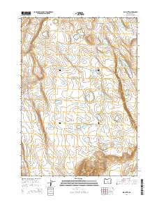
2014 Map of Elk Butte
USGS Topo · Published 2014About this map
Elk Butte and Elk Mtn dominate this high-desert landscape in Lake County, where water is the defining resource for ranching and wildlife. The distribution of named springs and catchments such as Immigrant Waterhole, Bourbon Waterhole, and Jewel Waterhole reveals the critical infrastructure of the high range. The topography is marked by volcanic features like Black Rim and the isolated peak of Fredrick Butte, connected by Bureau of Land Management routes including BLM 6111-0-80. The name Emigrant appearing along the northern elevations suggests the historical passage of travelers through this arid corridor. This 2014 survey captures the persistence of traditional land use and the reliance on scattered water sources like Schlitz Waterhole and Best Waterhole across the high plateaus.
Find a feature on this map
28 named features on this map. Tap any name to fly to it.
Don’t see what you’re looking for? This feature index may not catch every label — zoom into the map to look around manually.
Map Details
Editions of this 2014 Elk Butte Map
This is the sole edition of this map. No revisions or reprints were ever made.
Other maps of this area

1955 · Crescent
USGS Topo · 1:250,000

1957 · Crescent
USGS Topo · 1:250,000

1958 · Crescent
USGS Topo · 1:250,000

1970 · Crescent
USGS Topo · 1:250,000
1981 · Tired Horse Butte
USGS Topo · 1:24,000

1981 · Sand Rock
USGS Topo · 1:24,000

1981 · Moonlight Butte
USGS Topo · 1:24,000

1981 · Elk Butte
USGS Topo · 1:24,000
1981 · Rams Butte
USGS Topo · 1:24,000

1981 · Chicago Valley
USGS Topo · 1:24,000