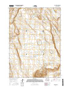
2017 Map of Elk Butte
USGS Topo · Published 2017About this map
Immigrant Waterhole and other vital desert water sources define this high-altitude landscape in Lake County during the early 21st century. The terrain is characterized by a series of shallow basins and isolated high points, most notably Elk Butte and Elk Mtn rising in the southern portion of the quadrangle. These names, along with Dragon Rock and the long basaltic edge of Black Rim, suggest a history of early travel and livestock grazing in this arid region of the Oregon high desert.
Find a feature on this map
16 named features on this map. Tap any name to fly to it.
Don’t see what you’re looking for? This feature index may not catch every label — zoom into the map to look around manually.
Map Details
Editions of this 2017 Elk Butte Map
This is the sole edition of this map. No revisions or reprints were ever made.
Other maps of this area

1955 · Crescent
USGS Topo · 1:250,000

1957 · Crescent
USGS Topo · 1:250,000

1958 · Crescent
USGS Topo · 1:250,000

1970 · Crescent
USGS Topo · 1:250,000
1981 · Tired Horse Butte
USGS Topo · 1:24,000

1981 · Sand Rock
USGS Topo · 1:24,000

1981 · Moonlight Butte
USGS Topo · 1:24,000

1981 · Elk Butte
USGS Topo · 1:24,000
1981 · Rams Butte
USGS Topo · 1:24,000

1981 · Chicago Valley
USGS Topo · 1:24,000