
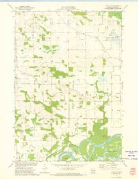
1972 Map of Elk Creek Lake
USGS Topo · Published 1975This historical map portrays the area of Elk Creek Lake in 1972, primarily covering Dunn County as well as portions of Eau Claire County and Chippewa County. Featuring a scale of 1:24000, this map provides a highly detailed snapshot of the terrain, roads, buildings, counties, and historical landmarks in the Elk Creek Lake region at the time. Published in 1975, it is the sole known edition of this map.
Find a feature on this map
46 named features on this map. Tap any name to fly to it.
Don’t see what you’re looking for? This feature index may not catch every label — zoom into the map to look around manually.
Map Details
Editions of this 1972 Elk Creek Lake Map
This is the sole edition of this map. No revisions or reprints were ever made.
Historical Maps of Elk Creek Lake Through Time
14 maps found

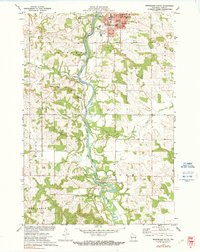
1972 Colfax South
Dunn County, WI

1972 Durand North
Dunn County, WI
1972 Elk Creek Lake
Dunn County, WI
1972 Falls City
Dunn County, WI

1972 Menomonie North
Dunn County, WI
1972 Menomonie South
Dunn County, WI

1972 Meridean
Dunn County, WI

1972 Rusk
Dunn County, WI

1974 Weston
Dunn County, WI

1975 Colfax North
Dunn County, WI

1975 Connorsville
Dunn County, WI

1975 Norton
Dunn County, WI

1975 Ridgeland NE
Dunn County, WI

1975 Sand Creek
Dunn County, WI