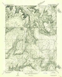
1954 Map of Elk Ridge 3 NW
USGS Topo · Published 1954About this map
Manti-La Sal National Forest defines the high-altitude topography of this southeastern Utah landscape, where vertical relief is marked by prominent benchmarks like Bears Ears VABM 8920 and The Hub VABM 8389. The map details a complex system of plateaus and drainage systems, notably Deer Flat and the intricate reaches of Deer Canyon and Cherry Canyon. Pockets of level ground among the steep terrain appear as named open spaces, including Upper Parks and the curiously named Lower Lost Parks. This preliminary edition, derived from 1951 aerial photography, serves as a record of mid-century land use in the high desert, identifying isolated water sources such as Twin Springs and small reservoirs near the enigmatic settlement or landmark known as The Hideout. The isolation of the terrain is further highlighted by labels like Piñon Point and Brushy Knoll, reflecting a landscape primarily shaped by natural features and sparse grazing or forest management infrastructure.
Find a feature on this map
14 named features on this map. Tap any name to fly to it.
Don’t see what you’re looking for? This feature index may not catch every label — zoom into the map to look around manually.
Map Details
Editions of this 1954 Elk Ridge 3 NW Map
This is the sole edition of this map. No revisions or reprints were ever made.
Other maps of this area

1886 · Henry Mountains
USGS Topo · 1:250,000

1886 · Abajo
USGS Topo · 1:250,000

1892 · Abajo
USGS Topo · 1:250,000

1892 · Henry Mountains
USGS Topo · 1:250,000

1893 · Abajo
USGS Topo · 1:250,000

1935 · Elk Ridge
USGS Topo · 1:96,000

1940 · Elk Ridge
USGS Topo · 1:125,000

1952 · Mouth of Dark Canyon
USGS Topo · 1:62,500

1952 · Natural Bridges
USGS Topo · 1:62,500

1954 · White Canyon 4 NE
USGS Topo · 1:24,000