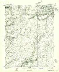
1954 Map of Elk Ridge 3 SW
USGS Topo · Published 1954About this map
Natural Bridges Nat Mon and its ancient architectural sites dominate the southwest corner of this mid-century survey. Within the deep recesses of Armstrong Canyon, several Cliff Dwellings and a Natural Bridge appear, illustrating the area’s prehistoric significance. The map traces the diagonal path of the Mormon Trail across the high plateaus of Harmony Flat and Grand Flat, providing a detailed record of this historic transit corridor through the San Juan backcountry. High-elevation features like Maverick Point and the Maverick Spring sit within the Manti-La Sal National Forest boundary, while the landscape breaks into the dramatic drainage of Grand Gulch and Kane Gulch. This 1952 mapping project captures the relationship between these prehistoric dwellings and the early pioneer routes that navigated the complex canyon systems of southeastern Utah.
Find a feature on this map
28 named features on this map. Tap any name to fly to it.
Don’t see what you’re looking for? This feature index may not catch every label — zoom into the map to look around manually.
Map Details
Editions of this 1954 Elk Ridge 3 SW Map
This is the sole edition of this map. No revisions or reprints were ever made.
Other maps of this area

1886 · Henry Mountains
USGS Topo · 1:250,000

1886 · Abajo
USGS Topo · 1:250,000

1892 · Abajo
USGS Topo · 1:250,000

1892 · Henry Mountains
USGS Topo · 1:250,000

1893 · Abajo
USGS Topo · 1:250,000

1935 · Elk Ridge
USGS Topo · 1:96,000

1940 · Elk Ridge
USGS Topo · 1:125,000

1952 · Natural Bridges
USGS Topo · 1:62,500

1954 · White Canyon 4 NE
USGS Topo · 1:24,000

1954 · White Canyon 4 SE
USGS Topo · 1:24,000