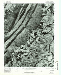
1977 Map of Elkton West
USGS Topo · Published 1983About this map
Massanutten Mountain dominates the western half of this 1977 orthophotograph, its ridge line punctuated by Runkles Gap. The imagery captures a distinct transition between the heavily forested slopes and the intricate patchwork of farmland in the Shenandoah Valley. Along the eastern edge, the South Fork Shenandoah River snakes past the settlements of Shenandoah and Elkton, revealing the historical dependence of these communities on the river corridor for commerce and transport. The aerial perspective provides a unique view of field patterns and rural development around smaller hamlets like East Point, Solsburg, and Mc Gaheysville. Notable water features including Cub Run and Boone Run cut across the lowlands, while Hopkins Spring remains a localized landmark in this corner of Rockingham County. This orthophotoquad format emphasizes land use and vegetation density more clearly than a standard topographic map.
Find a feature on this map
11 named features on this map. Tap any name to fly to it.
Don’t see what you’re looking for? This feature index may not catch every label — zoom into the map to look around manually.
Map Details
Editions of this 1977 Elkton West Map
This is the sole edition of this map. No revisions or reprints were ever made.
Other maps of this area

1892 · Woodstock
USGS Topo · 1:125,000

1892 · Harrisonburg
USGS Topo · 1:125,000

1937 · Elkton
USGS Topo · 1:62,500

1941 · Harrisonburg
USGS Topo · 1:62,500

1942 · Mt Jackson
USGS Topo · 1:62,500

1943 · Harrisonburg
USGS Topo · 1:62,500

1946 · Mt Jackson
USGS Topo · 1:62,500

1947 · Mt Jackson
USGS Topo · 1:62,500

1947 · Broadway
USGS Topo · 1:62,500

1949 · Charlottesville
USGS Topo · 1:250,000