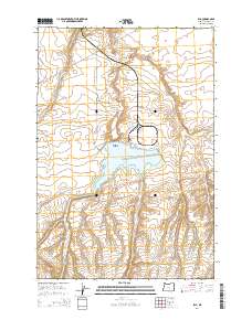
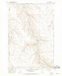
2014 Map of Ella
USGS Topo · Published 2014About this map
Ella sits in the southern portion of this Morrow County landscape, a settlement positioned near the crossing of Immigrant Ln and Ella Rd. The terrain is defined by its water management and topographical landmarks, most notably the expansive Carty Reservoir which dominates the central part of the quadrangle. North of the reservoir, Poverty Ridge rises above the surrounding canyons, including Sixmile Canyon and Fourmile Canyon. The road network, including Taggares Ln and Six Mile Canyon Rd, reflects a rural infrastructure designed around the natural drainage systems and agricultural needs of the region. To the southwest, Lone Butte serves as a prominent elevation marker, standing apart from the primary ridge systems. The presence of Immigrant Ln suggests historical transportation corridors that have been formalized into the modern local road system.
Find a feature on this map
14 named features on this map. Tap any name to fly to it.
Don’t see what you’re looking for? This feature index may not catch every label — zoom into the map to look around manually.
Map Details
Editions of this 2014 Ella Map
This is the sole edition of this map. No revisions or reprints were ever made.
Other maps of this area
1906 · Blalock Island
USGS Topo · 1:125,000
1908 · Blalock Island
USGS Topo · 1:125,000

1953 · Pendleton
USGS Topo · 1:250,000

1956 · Pendleton
USGS Topo · 1:250,000
1962 · Alderdale
USGS Topo · 1:24,000
1962 · Boardman
USGS Topo · 1:24,000
1962 · Crow Butte
USGS Topo · 1:24,000
1968 · Ione North
USGS Topo · 1:24,000
1968 · Dalreed Butte
USGS Topo · 1:24,000
1968 · Cecil
USGS Topo · 1:24,000