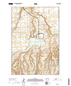
2020 Map of Ella
USGS Topo · Published 2020About this map
Ella anchors this portion of Morrow County, where the high desert terrain is defined by deep draws and prominent volcanic rises. The centralized Carty Reservoir serves as a critical water source in an arid landscape dominated by the elevated Poverty Ridge and the winding course of Fourmile Canyon. The region's transport network is sparse, consisting of rural routes like Tower Rd and Taggares Ln that navigate around the distinct formation of Lone Butte. Historically significant pathways are reflected in local naming conventions, such as Immigrant Ln, hinting at the ancestral routes through the Oregon interior. The map clearly delineates township boundaries including t3n r24e and t2n r24e, illustrating the systematic land divisions that have governed this agricultural and ranching territory since its settlement.
Find a feature on this map
10 named features on this map. Tap any name to fly to it.
Don’t see what you’re looking for? This feature index may not catch every label — zoom into the map to look around manually.
Map Details
Editions of this 2020 Ella Map
This is the sole edition of this map. No revisions or reprints were ever made.
Other maps of this area

1906 · Blalock Island
USGS Topo · 1:125,000

1908 · Blalock Island
USGS Topo · 1:125,000

1953 · Pendleton
USGS Topo · 1:250,000

1956 · Pendleton
USGS Topo · 1:250,000

1962 · Alderdale
USGS Topo · 1:24,000

1962 · Boardman
USGS Topo · 1:24,000

1962 · Crow Butte
USGS Topo · 1:24,000

1968 · Ione North
USGS Topo · 1:24,000
1968 · Dalreed Butte
USGS Topo · 1:24,000
1968 · Cecil
USGS Topo · 1:24,000