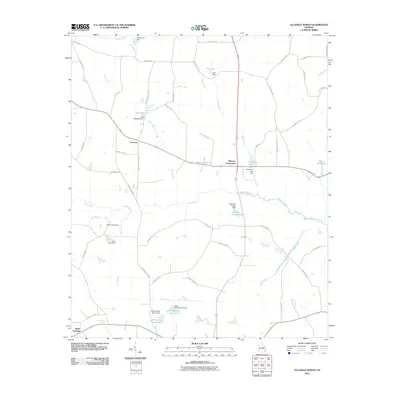
2011 Map of Ellaville North
USGS Topo · Published 2011About this map
Concord and Murrays Crossroads serve as central nodes for this agricultural landscape in Schley County, Georgia. The region is defined by a dense network of water bodies and small-scale dams, many of which appear to support private ponds and former mill sites. Features such as Hills Millpond and Brays Mill Pond suggest a history of local water-powered industry, while family-named landmarks like Rufus Peepe Lake North and Wells Lake provide specific points of interest for genealogists tracing regional land ownership. The hydrology is dominated by the winding paths of Coon Creek and Buck Creek, which are fed by numerous small tributaries like Rice Branch and Fox Branch. This rural infrastructure is linked by a grid of named roads including Bridges Store Rd and Possum Trot Rd, reflecting the community's long-standing connection to the land.
Find a feature on this map
63 named features on this map. Tap any name to fly to it.
Don’t see what you’re looking for? This feature index may not catch every label — zoom into the map to look around manually.
Map Details
Editions of this 2011 Ellaville North Map
This is the sole edition of this map. No revisions or reprints were ever made.
Other maps of this area

1955 · Phenix City
USGS Topo · 1:250,000

1957 · Phenix City
USGS Topo · 1:250,000

1958 · Phenix City
USGS Topo · 1:250,000

1971 · Rupert
USGS Topo · 1:24,000

1971 · Ideal South
USGS Topo · 1:24,000

1971 · Ideal North
USGS Topo · 1:24,000

1971 · Ellaville North
USGS Topo · 1:24,000

1971 · Tazewell South
USGS Topo · 1:24,000
1971 · Tazewell North
USGS Topo · 1:24,000

1972 · Ellaville South
USGS Topo · 1:24,000