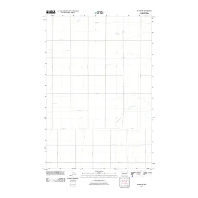
2011 Map of Elliott SE
USGS Topo · Published 2011About this map
The agricultural grid of Ransom County dominates this 2011 survey, reflecting the highly structured section-line development typical of North Dakota's eastern plains. The landscape is primarily organized by a rigid network of gravel and section roads, such as 122nd Ave SE and 80th St SE, which define the boundaries of large-scale farming tracts. Breaking this geometric pattern is the winding path of Dead Colt Creek, which meanders through the southeastern portion of the quadrangle. This drainage feature and its associated wetlands provide the only major natural relief in an otherwise strictly partitioned terrain. The scarcity of named settlements or civic structures highlights the area's specialized role in regional agriculture during the early 21st century, where the focus remained on land management and water drainage rather than town-site expansion.
Find a feature on this map
16 named features on this map. Tap any name to fly to it.
Don’t see what you’re looking for? This feature index may not catch every label — zoom into the map to look around manually.
Map Details
Editions of this 2011 Elliott SE Map
This is the sole edition of this map. No revisions or reprints were ever made.
Other maps of this area

1952 · Crete
USGS Topo · 1:24,000

1953 · Fargo
USGS Topo · 1:250,000

1956 · Fargo
USGS Topo · 1:250,000

1957 · Elliott SW
USGS Topo · 1:24,000

1957 · Stirum
USGS Topo · 1:24,000

1957 · Elliott SE
USGS Topo · 1:24,000
1962 · Englevale
USGS Topo · 1:24,000

1962 · Lisbon
USGS Topo · 1:24,000

1962 · Lisbon SW
USGS Topo · 1:24,000

1962 · Elliott
USGS Topo · 1:24,000
Featured Places
- Elliott Township, ND
- Vivian Township, ND
- Whitestone Hill Township, ND
- Island Park Township, ND
- Bale Township, ND