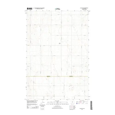
2014 Map of Elliott SE
USGS Topo · Published 2014About this map
The agricultural landscape along the boundary of Ransom Co and Sargent Co is defined by a grid of section-line roads and subtle drainage patterns characteristic of the Red River Valley’s western edge. The drainage of Dead Colt Cr meanders through the eastern portion of the survey area, while Timber Coulee provides relief to the central terrain. This 2014 survey documents a modern rural network where arterial routes like CR-3711 and a dense system of numbered township roads, such as 125th Ave SE and 78th St SE, provide access to farmsteads and field boundaries. The map illustrates the precision of the Public Land Survey System, showing how transportation and property lines remain strictly anchored to the cardinal-direction grid despite the natural diversions of the local coulees.
Find a feature on this map
20 named features on this map. Tap any name to fly to it.
Don’t see what you’re looking for? This feature index may not catch every label — zoom into the map to look around manually.
Map Details
Editions of this 2014 Elliott SE Map
This is the sole edition of this map. No revisions or reprints were ever made.
Other maps of this area

1952 · Crete
USGS Topo · 1:24,000

1953 · Fargo
USGS Topo · 1:250,000

1956 · Fargo
USGS Topo · 1:250,000

1957 · Elliott SW
USGS Topo · 1:24,000

1957 · Stirum
USGS Topo · 1:24,000

1957 · Elliott SE
USGS Topo · 1:24,000
1962 · Englevale
USGS Topo · 1:24,000

1962 · Lisbon
USGS Topo · 1:24,000

1962 · Lisbon SW
USGS Topo · 1:24,000

1962 · Elliott
USGS Topo · 1:24,000
Featured Places
- Elliott Township, ND
- Vivian Township, ND
- Whitestone Hill Township, ND
- Island Park Township, ND
- Bale Township, ND