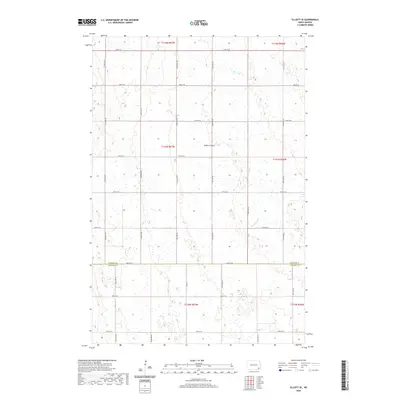
2020 Map of Elliott SE
USGS Topo · Published 2020About this map
The Ransom Co Sargent Co boundary line divides this prairie landscape, where a rigorous grid of section lines and gravel roads dictates the movement of people and commerce. In the northern half, Timber Coulee winds through the terrain, while the southern portion is defined by the meandering course of Dead Colt Cr. This survey illustrates the classic Public Land Survey System organization of the Dakotas, showing the townships of t133n r57w and t133n r56w alongside their neighbors. The absence of concentrated settlements highlights the area's specialized agricultural character, with long, straight thoroughfares like 124th Ave Se and Co Rd 4 serving as the primary arteries for a dispersed rural population. The numerous small wetlands and depressions shown across the sheet are characteristic of the region's post-glacial topography.
Find a feature on this map
26 named features on this map. Tap any name to fly to it.
Don’t see what you’re looking for? This feature index may not catch every label — zoom into the map to look around manually.
Map Details
Editions of this 2020 Elliott SE Map
This is the sole edition of this map. No revisions or reprints were ever made.
Other maps of this area

1952 · Crete
USGS Topo · 1:24,000

1953 · Fargo
USGS Topo · 1:250,000

1956 · Fargo
USGS Topo · 1:250,000

1957 · Elliott SW
USGS Topo · 1:24,000

1957 · Stirum
USGS Topo · 1:24,000

1957 · Elliott SE
USGS Topo · 1:24,000
1962 · Englevale
USGS Topo · 1:24,000

1962 · Lisbon
USGS Topo · 1:24,000

1962 · Lisbon SW
USGS Topo · 1:24,000

1962 · Elliott
USGS Topo · 1:24,000
Featured Places
- Elliott Township, ND
- Vivian Township, ND
- Whitestone Hill Township, ND
- Island Park Township, ND
- Bale Township, ND