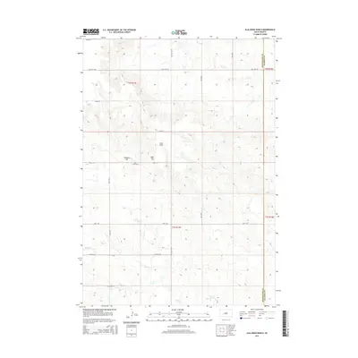
2015 Map of Elm Creek Ranch
USGS Topo · Published 2015About this map
Elm Creek Ranch sits at the heart of this Pennington County landscape, where the High Plains terrain is carved by the drainages of Poeno Cr and Elm Cr. The map reveals a remote ranching territory defined by its water sources and high points, including Hubbard Hill and Bliss Hill. An intricate network of section-line roads and tracks, such as Wolf Rd and Paulsen Rd, connects the scattered homesteads across this expansive prairie.
Find a feature on this map
20 named features on this map. Tap any name to fly to it.
Don’t see what you’re looking for? This feature index may not catch every label — zoom into the map to look around manually.
Map Details
Editions of this 2015 Elm Creek Ranch Map
This is the sole edition of this map. No revisions or reprints were ever made.
Other maps of this area

1953 · Rapid City
USGS Topo · 1:250,000

1954 · Pierre
USGS Topo · 1:250,000

1955 · Hot Springs
USGS Topo · 1:250,000

1955 · Martin
USGS Topo · 1:250,000

1957 · Rapid City
USGS Topo · 1:250,000

1958 · Pierre
USGS Topo · 1:250,000

1958 · Martin
USGS Topo · 1:250,000
1960 · Wall
USGS Topo · 1:24,000
1961 · Cottonwood
USGS Topo · 1:24,000
1961 · Wall NE
USGS Topo · 1:24,000