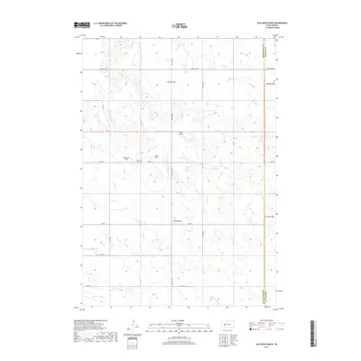
2017 Map of Elm Creek Ranch
USGS Topo · Published 2017About this map
Elm Creek Ranch sits at the heart of this high plains landscape on the border of Pennington and Haakon counties. The terrain is defined by a network of seasonal watercourses and prominent rises, including Hubbard Hill and Bliss Hill. Drainage patterns are clearly marked by Elm Cr and Lake Cr, which carve through the prairie towards Lost Draw. The sparse road network, featuring routes like Big Foote Rd and Kelly Hill Rd, reflects the expansive, ranch-centered layout of the region. This 2017 survey details the section lines and township boundaries, such as t2n r17e, that organize this western South Dakota range land.
Find a feature on this map
19 named features on this map. Tap any name to fly to it.
Don’t see what you’re looking for? This feature index may not catch every label — zoom into the map to look around manually.
Map Details
Editions of this 2017 Elm Creek Ranch Map
This is the sole edition of this map. No revisions or reprints were ever made.
Other maps of this area

1953 · Rapid City
USGS Topo · 1:250,000

1954 · Pierre
USGS Topo · 1:250,000

1955 · Hot Springs
USGS Topo · 1:250,000

1955 · Martin
USGS Topo · 1:250,000

1957 · Rapid City
USGS Topo · 1:250,000

1958 · Pierre
USGS Topo · 1:250,000

1958 · Martin
USGS Topo · 1:250,000
1960 · Wall
USGS Topo · 1:24,000
1961 · Cottonwood
USGS Topo · 1:24,000
1961 · Wall NE
USGS Topo · 1:24,000