1909 Map of Elmira
USGS Topo · Published 1909About this map
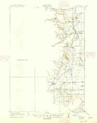
The Long Tom River and its meandering tributaries dominate this 1909 survey of Lane County, Oregon. The landscape is defined by its transition from the valley floor to the foothills, marked by distinctive landforms such as Richardson Butte and Cemetery Butte. Settlement patterns at this time follow the water and early transportation routes, with small communities like Elmira and Smithfield serving as local hubs. The importance of the timber industry is evident at Perkins Mill along the Siuslaw Road, while the numerous rural educational sites, including Duckpond School and Lower Fern Ridge School, reflect a decentralized agricultural society before the consolidation of the mid-20th century. The Southern Pacific railroad and the Oregon Electric line provide the critical connections to the broader Willamette Valley, anchoring towns like Cheshire and Veneta during an era of significant regional growth.
Find a feature on this map
43 named features on this map. Tap any name to fly to it.
Don’t see what you’re looking for? This feature index may not catch every label — zoom into the map to look around manually.
Map Details
Editions of this 1909 Elmira Map
This is the sole edition of this map. No revisions or reprints were ever made.
Historical Maps of Veneta Through Time
4 maps found