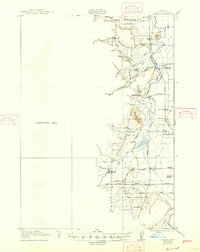
1922 Map of Elmira
USGS Topo · Published 1947About this map
Long Tom River flows through this Willamette Valley landscape, where the early 20th-century economy relied on timber and transportation. The presence of Perkins Mill and a local Sawmill underscores the importance of the logging industry, while the Southern Pacific and Oregon Electric railroads facilitated the movement of goods through junctions like Cheshire. This area is particularly dense with rural community institutions, featuring an extensive network of schoolhouses including Liberty School, Duckpond School, and Upper Fern Ridge School.
Find a feature on this map
39 named features on this map. Tap any name to fly to it.
Don’t see what you’re looking for? This feature index may not catch every label — zoom into the map to look around manually.
Map Details
Editions of this 1922 Elmira Map
3 editions found
Other maps of this area

1909 · Harrisburg
USGS Topo · 1:31,680

1909 · Elmira
USGS Topo · 1:62,500

1910 · Eugene
USGS Topo · 1:62,500

1911 · Monroe
USGS Topo · 1:31,680

1912 · Halsey
USGS Topo · 1:62,500

1921 · Cottage Grove
USGS Topo · 1:62,500

1922 · Monroe
USGS Topo · 1:62,500

1922 · Elmira
USGS Topo · 1:62,500

1939 · Monroe
USGS Topo · 1:62,500

1940 · Eugene
USGS Topo · 1:62,500