1909 Map of Harrisburg
USGS Topo · Published 1909About this map
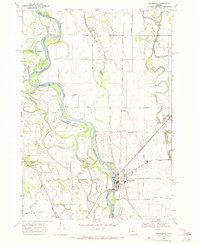
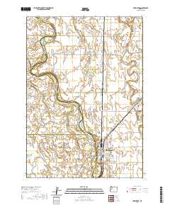
The Willamette River dominates this Willamette Valley landscape, its braided channels creating a complex network of islands and sloughs such as Morgan Island, Round Island, and the long Island Line. Surveyed in 1909 by geographers like T. G. Gerdine, the map documents a transition in regional transportation. While the Southern Pacific railroad cuts through the terrain, older river-crossing methods remain vital, evidenced by Ingrams Ferry and the Free County Ferry at Harrisburg. The distribution of rural education is remarkably dense, with a chain of schoolhouses including Lake Creek School, Busey School, and Harmony School serving the farming families of Lane, Linn, and Benton counties. These small school districts and the meandering course of Muddy Creek define the early 20th-century character of these settlements.
Find a feature on this map
25 named features on this map. Tap any name to fly to it.
Don’t see what you’re looking for? This feature index may not catch every label — zoom into the map to look around manually.
Map Details
Editions of this 1909 Harrisburg Map
This is the sole edition of this map. No revisions or reprints were ever made.
Historical Maps of Harrisburg Through Time
7 maps found