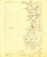
1922 Map of Elmira
USGS Topo · Published 1929About this map
Elmira and Veneta anchor the southern portion of this Lane County landscape, where the Southern Pacific railroad parallels the modern Siuslaw Highway. The map captures a transitional rural economy, featuring established timber and agricultural infrastructure like Perkins Mill alongside a dense network of country schools, including Redoak School, Fir Butte School, and the Upper Fern Ridge and Lower Fern Ridge sites.
Find a feature on this map
42 named features on this map. Tap any name to fly to it.
Don’t see what you’re looking for? This feature index may not catch every label — zoom into the map to look around manually.
Map Details
Editions of this 1922 Elmira Map
3 editions found
Other maps of this area

1909 · Harrisburg
USGS Topo · 1:31,680

1909 · Elmira
USGS Topo · 1:62,500

1910 · Eugene
USGS Topo · 1:62,500

1911 · Monroe
USGS Topo · 1:31,680

1912 · Halsey
USGS Topo · 1:62,500

1921 · Cottage Grove
USGS Topo · 1:62,500

1922 · Monroe
USGS Topo · 1:62,500

1922 · Elmira
USGS Topo · 1:62,500

1939 · Monroe
USGS Topo · 1:62,500

1940 · Eugene
USGS Topo · 1:62,500