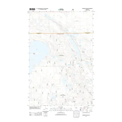
2013 Map of Elmwood Island
USGS Topo · Published 2013About this map
Chippewa National Forest dominates this landscape on the border of Koochiching and Itasca counties. This terrain is defined by a dense network of glacial lakes and managed waterways, including the Welch Lake Impoundment and Eel Lake Impoundment. These water management features, alongside the Wagner Lake Lookout Tower in the south, reflect a century of federal forestry and conservation efforts in northern Minnesota.
Find a feature on this map
32 named features on this map. Tap any name to fly to it.
Don’t see what you’re looking for? This feature index may not catch every label — zoom into the map to look around manually.
Map Details
Editions of this 2013 Elmwood Island Map
This is the sole edition of this map. No revisions or reprints were ever made.
Other maps of this area

1919 · Rosy
USGS Topo · 1:62,500

1919 · Gemmell
USGS Topo · 1:62,500

1919 · Max
USGS Topo · 1:62,500

1919 · Bridgie
USGS Topo · 1:62,500

1924 · Bridgie
USGS Topo · 1:62,500

1954 · Bemidji
USGS Topo · 1:250,000

1957 · Bemidji
USGS Topo · 1:250,000

1958 · Bemidji
USGS Topo · 1:250,000

1971 · Squaw Lake
USGS Topo · 1:24,000
1971 · Dora Lake
USGS Topo · 1:24,000