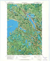
1971 Map of Elmwood Island
USGS Topo · Published 1974About this map
The jurisdictional boundary between Koochiching and Itasca counties runs through a dense network of timberlands and glacial lakes in this early 1970s orthophotomap. The landscape is defined by the intersection of several managed wilderness areas, including Chippewa National Forest, Koochiching State Forest, and Pine Island State Forest. These forests are punctuated by a high density of water bodies, most notably the expansive Island Lake featuring Elmwood Island and the long, irregular reach of Moose Lake. Evidence of local industry and infrastructure appears in the form of a Gravel Pit and the Wagner Lake Lookout Tower, positioned near Wagner Lake in the Blackduck State Forest. The map uses a photographic base to reveal the intricate patterns of wetland vegetation and forest cover that separate smaller named waters like Hendrickson Lake, Fiske Lake, and Eel Lake.
Find a feature on this map
26 named features on this map. Tap any name to fly to it.
Don’t see what you’re looking for? This feature index may not catch every label — zoom into the map to look around manually.
Map Details
Editions of this 1971 Elmwood Island Map
This is the sole edition of this map. No revisions or reprints were ever made.
Other maps of this area

1919 · Rosy
USGS Topo · 1:62,500

1919 · Gemmell
USGS Topo · 1:62,500

1919 · Max
USGS Topo · 1:62,500

1919 · Bridgie
USGS Topo · 1:62,500

1924 · Bridgie
USGS Topo · 1:62,500

1954 · Bemidji
USGS Topo · 1:250,000

1957 · Bemidji
USGS Topo · 1:250,000

1958 · Bemidji
USGS Topo · 1:250,000

1971 · Squaw Lake
USGS Topo · 1:24,000
1971 · Dora Lake
USGS Topo · 1:24,000