Loading...
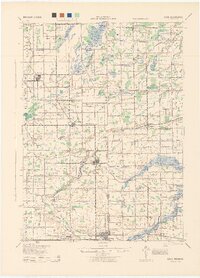
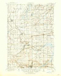
Loading map...1943 Map of Elsie
USGS Topo · Published 1944About this map
The Maple River winds through this central Michigan landscape, defining the rural character of Clinton, Gratiot, Saginaw, and Shiawassee counties. In the early 1940s, the region was a network of small agricultural hubs connected by the Ann Arbor and Grand Trunk railroads. The village of Elsie serves as a central point, surrounded by an exceptionally dense distribution of rural schoolhouses, including School No 5, Watson Sch, and Richards Sch.
Find a feature on this map
70 named features on this map. Tap any name to fly to it.
Don’t see what you’re looking for? This feature index may not catch every label — zoom into the map to look around manually.
Map Details
Date Portrayed1943
Date Published1944
PublisherU.S. Geological Survey
Map TypeTopographic
Scale1:62,500
Physical Dimensions16.05 x 22.29 inches
Editions of this 1943 Elsie Map
This is the sole edition of this map. No revisions or reprints were ever made.
Historical Maps of Ovid Through Time
Featured Locations
- Ashley, Elba Township
- Chapin, Chapin Township
- Duplain, Duplain Township
- Elsie, Duplain Township
- Ovid, Ovid Township
Source Details
SourceU.S. Geological Survey
CopyrightPublic Domain