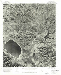
1974 Map of Elsinore
USGS Topo · Published 1977About this map
Lake Elsinore dominates the southwestern corner of this 1974 orthophotoquad, its dark waters contrasting sharply with the developed shoreline of Lakeland Village. Produced from aerial photography taken in early November, the imagery provides a photographic record of the region's mid-1970s footprint, centered on the city of Elsinore. To the east, the dramatic canyon terrain is punctuated by the Railroad Canyon Reservoir, while the Sedco Hills area reveals the early patterns of residential and agricultural expansion. This specialized survey, created by the U.S. Geological Survey in cooperation with the U. S. Soil Conservation Service, uses scanned photoimagery to document land use and drainage patterns during a period of transition for this part of Riverside County.
Find a feature on this map
5 named features on this map. Tap any name to fly to it.
Don’t see what you’re looking for? This feature index may not catch every label — zoom into the map to look around manually.
Map Details
Editions of this 1974 Elsinore Map
This is the sole edition of this map. No revisions or reprints were ever made.
Other maps of this area

1901 · Southern California Sheet No. 1
USGS Topo · 1:250,000

1901 · Elsinore
USGS Topo · 1:125,000

1901 · Riverside
USGS Topo · 1:62,500

1904 · Southern California Sheet No. 1
USGS Topo · 1:250,000

1942 · Lake Elsinore
USGS Topo · 1:62,500

1942 · Murrieta
USGS Topo · 1:62,500

1942 · Riverside
USGS Topo · 1:62,500

1942 · Perris
USGS Topo · 1:62,500

1943 · Perris
USGS Topo · 1:62,500

1943 · Riverside
USGS Topo · 1:62,500