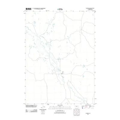
2011 Map of Elsmere
USGS Topo · Published 2011About this map
Elsmere occupies a remote pocket of Cherry County, serving as a vital central point in a landscape defined by water and ranching routes. This survey highlights the local prominence of the Elsmere Post Office and the Giles Cemetery, which together anchor the community's history and genealogy. The meandering path of Goose Creek dominates the hydrology of the area, creating a network of small ponds and wetlands that dictate the placement of roads and homesteads. Local transportation is facilitated by thoroughfares such as Elsmere Rd and N Loup River Rd, which connect these isolated settlements across the Nebraska sandhills. The map reflects a 21st-century view of a traditional rural landscape where geography remains the primary driver of human presence.
Find a feature on this map
6 named features on this map. Tap any name to fly to it.
Don’t see what you’re looking for? This feature index may not catch every label — zoom into the map to look around manually.
Map Details
Editions of this 2011 Elsmere Map
This is the sole edition of this map. No revisions or reprints were ever made.
Other maps of this area

1949 · Purdum
USGS Topo · 1:62,500

1949 · Koshopah
USGS Topo · 1:62,500

1949 · Long Lake
USGS Topo · 1:62,500

1951 · Long Lake
USGS Topo · 1:62,500

1951 · Purdum
USGS Topo · 1:62,500

1951 · Moon Lake
USGS Topo · 1:62,500

1951 · Koshopah
USGS Topo · 1:62,500

1957 · Valentine
USGS Topo · 1:250,000

1959 · Valentine
USGS Topo · 1:250,000
1985 · Long Lake SE
USGS Topo · 1:24,000