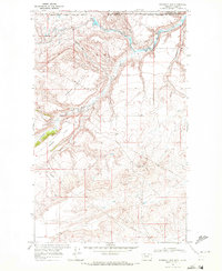
1968 Map of Emigrant Gap
USGS Topo · Published 1972About this map
Emigrant Gap sits at the international boundary in the late 1960s, marking a rugged point of passage where the high plains of Glacier County meet the Alberta border. This landscape is defined by the complex water management systems of the Saint Mary Canal, which winds across the northern terrain to feed the North Fork Milk River. The map captures a largely unpopulated expanse of grazing land and coulees, including the wide plateau of Hungry Horse Flat and the depressions of The Basin. The border itself is meticulously delineated, showing the Blackfeet Indian Res Bdy and the transition into the Lethbridge District. Scattered infrastructure like the Gaging Sta and a Gravel Pit near Dubay Coulee point to the limited but vital human activity in this remote ranching and irrigation corridor.
Find a feature on this map
18 named features on this map. Tap any name to fly to it.
Don’t see what you’re looking for? This feature index may not catch every label — zoom into the map to look around manually.
Map Details
Editions of this 1968 Emigrant Gap Map
This is the sole edition of this map. No revisions or reprints were ever made.
Other maps of this area

1901 · Browning
USGS Topo · 1:125,000

1903 · Browning
USGS Topo · 1:125,000

1911 · Blackfoot
USGS Topo · 1:125,000

1960 · Cut Bank
USGS Topo · 1:250,000

1963 · Cut Bank
USGS Topo · 1:250,000

1964 · Cut Bank
USGS Topo · 1:250,000

1968 · Hoodoo Hill
USGS Topo · 1:24,000
1968 · Hall Coulee
USGS Topo · 1:24,000
1968 · Wetzel
USGS Topo · 1:24,000
1968 · Bushnell Hill
USGS Topo · 1:24,000