
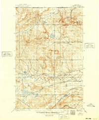
1911 Map of Blackfoot
USGS Topo · Published 1911About this map
The Blackfeet Indian Reservation dominates this 1907 survey, capturing a landscape of northern Montana defined by sprawling coulees and early ranching interests. The arrival of the Great Northern railroad across the southern portion of the sheet brought a new infrastructure of transit, establishing stops such as Blackfoot and Seville. The presence of the Cutfinger School and Cooks Ranch suggests the localized nature of community life at the turn of the century, where families were scattered among prominent natural landmarks like Horsethief Ridge and Landslide Butte. To the north, the Milk River and Kennedy Coulee carve through the high plains toward the United States Canada Boundary Line. This topography reflects the transition from a purely open range to a mapped territory defined by water rights and railway expansion, including features like Kipps Lake and the Two Medicine River.
Find a feature on this map
35 named features on this map. Tap any name to fly to it.
Don’t see what you’re looking for? This feature index may not catch every label — zoom into the map to look around manually.
Map Details
Editions of this 1911 Blackfoot Map
2 editions found
Other maps of this area

1901 · Browning
USGS Topo · 1:125,000

1903 · Browning
USGS Topo · 1:125,000

1907 · Blackfoot Res.
USGS Topo · 1:48,000

1909 · Cut Bank
USGS Topo · 1:125,000

1912 · Cut Bank
USGS Topo · 1:125,000

1913 · Marias Pass
USGS Topo · 1:125,000

1914 · Heart Butte
USGS Topo · 1:125,000

1918 · Heart Butte
USGS Topo · 1:125,000

1920 · Dupuyer
USGS Topo · 1:125,000

1934 · Lake Frances
USGS Topo · 1:48,000