1920 Map of Dupuyer
USGS Topo · Published 1920About this map
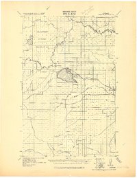
The Blackfeet Indian Reservation dominates the northern landscape of this 1920 advance sheet, where the Marias River and its numerous tributaries like Birch Creek and Two Medicine River carve paths across the high plains. This military compilation, produced under the direction of Col. Chas. L. Potter, captures the region as irrigation and rail expansion began to reshape the local economy. The town of Valier sits at the northern edge of the significant Lake Francis, serving as a hub for the Montana Western R. R.. Further south, the map details the early footprints of settlements like Pendroy, Williams, and Porter, situated along the coulees and creek beds. The document provides a clear view of the complex water systems, including the Dry Fork Marias River and Pondera Coulee, which were vital to the livestock and agricultural development of Teton and Toole counties.
Find a feature on this map
20 named features on this map. Tap any name to fly to it.
Don’t see what you’re looking for? This feature index may not catch every label — zoom into the map to look around manually.
Map Details
Editions of this 1920 Dupuyer Map
This is the sole edition of this map. No revisions or reprints were ever made.
Historical Maps of Valier Through Time
1 maps found