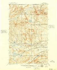
1911 Map of Blackfoot
USGS Topo · Published 1949About this map
The Blackfeet Indian Reservation dominates this 1907 survey, showing the vast transition from the United States Canada Boundary Line south toward the plains. The landscape is defined by the incision of Milk River and Cut Bank Creek, which carve through high plateaus like Horsethief Ridge and Carlow Flat. This era marks the early integration of the region into the national rail economy, as the Great Northern railroad tracks cross the southern portion of the map, supporting small siding settlements such as Bombay, Carlow, and Seville.
Find a feature on this map
38 named features on this map. Tap any name to fly to it.
Don’t see what you’re looking for? This feature index may not catch every label — zoom into the map to look around manually.
Map Details
Editions of this 1911 Blackfoot Map
2 editions found
Other maps of this area

1901 · Browning
USGS Topo · 1:125,000

1903 · Browning
USGS Topo · 1:125,000

1907 · Blackfoot Res.
USGS Topo · 1:48,000

1909 · Cut Bank
USGS Topo · 1:125,000

1911 · Blackfoot
USGS Topo · 1:125,000

1912 · Cut Bank
USGS Topo · 1:125,000

1913 · Marias Pass
USGS Topo · 1:125,000

1914 · Heart Butte
USGS Topo · 1:125,000

1918 · Heart Butte
USGS Topo · 1:125,000

1920 · Dupuyer
USGS Topo · 1:125,000