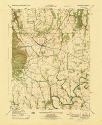
1945 Map of Emmitsburg
USGS Topo · Published 1945About this map
Emmitsburg serves as the central hub of this 1945 survey, situated just south of the Pennsylvania-Maryland border. The area is defined by its prominent educational and religious institutions, most notably Mount St. Marys College at the base of College Mountain and St. Josephs Academy. The landscape is a mix of small settlements and agricultural tracts, with local schools like Grayson School and Moritz School serving rural communities. Water plays a vital role in the geography here, with Toms Creek and Middle Creek flowing toward the Monocacy River in the south. The presence of Shanks Mill and the Six Bridge crossing suggest an economy still rooted in local milling and established river fords. Small hamlets such as St. Anthony, Motters, and Keysville are connected by a network of secondary roads that highlight the pre-war rural development of Frederick and Carroll Counties.
Find a feature on this map
38 named features on this map. Tap any name to fly to it.
Don’t see what you’re looking for? This feature index may not catch every label — zoom into the map to look around manually.
Map Details
Editions of this 1945 Emmitsburg Map
This is the sole edition of this map. No revisions or reprints were ever made.
Other maps of this area

1908 · Gettysburg
USGS Topo · 1:62,500

1909 · Fairfield
USGS Topo · 1:62,500

1911 · Taneytown
USGS Topo · 1:62,500

1911 · Emmitsburg
USGS Topo · 1:62,500

1942 · Gettysburg
USGS Topo · 1:125,000

1943 · Emmitsburg
USGS Topo · 1:62,500

1944 · Union Bridge
USGS Topo · 1:31,680
1944 · Catoctin Furnace
USGS Topo · 1:31,680

1944 · Gettysburg
USGS Topo · 1:31,680
1944 · Blue Ridge Summit
USGS Topo · 1:31,680