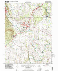
1999 Map of Emmitsburg
USGS Topo · Published 2001About this map
The Mason And Dixon Line serves as the northern boundary of this Maryland landscape, where the historic town of Emmitsburg sits at the base of College Mountain. This 1999 survey documents a region deeply rooted in Catholic education and heritage, centered on the sprawling grounds of St Josephs College and St Josephs Church. The terrain is defined by the drainage of Marsh Creek, Middle Creek, and Tom's Creek as they flow toward the Monocacy River in the southeast corner. Small agricultural hamlets such as Motters, Fourpoints, and Keysville are scattered across the valley, connected by country roads that cross landmarks like Sixes Bridge. To the west, the topography rises sharply into the wooded heights of Turkey Valley, providing a stark contrast to the rolling farmland and cemeteries like Mountain View Cem that characterize the Maryland-Pennsylvania borderlands.
Find a feature on this map
36 named features on this map. Tap any name to fly to it.
Don’t see what you’re looking for? This feature index may not catch every label — zoom into the map to look around manually.
Map Details
Editions of this 1999 Emmitsburg Map
This is the sole edition of this map. No revisions or reprints were ever made.
Other maps of this area

1908 · Gettysburg
USGS Topo · 1:62,500

1909 · Fairfield
USGS Topo · 1:62,500

1911 · Taneytown
USGS Topo · 1:62,500

1911 · Emmitsburg
USGS Topo · 1:62,500

1942 · Gettysburg
USGS Topo · 1:125,000

1943 · Emmitsburg
USGS Topo · 1:62,500

1944 · Union Bridge
USGS Topo · 1:31,680
1944 · Catoctin Furnace
USGS Topo · 1:31,680

1944 · Gettysburg
USGS Topo · 1:31,680
1944 · Blue Ridge Summit
USGS Topo · 1:31,680