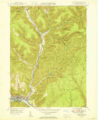
1950 Map of Emporium
USGS Topo · Published 1950About this map
Emporium sits at the southern edge of this mid-century Pennsylvania mountain landscape, where the Driftwood Branch Sinnemahoning Creek and Sinnemahoning Creek converge. This survey shows the area's transition from an industrial and rail-dependent corridor to a landscape defined by state conservation efforts. The Pennsylvania railroad line tracks the valley floor north through Sizerville and Gardeau, while the uplands are etched with a dense network of timbering and hiking routes like the Buffalo Switch Trail and McDowell Trail.
Find a feature on this map
85 named features on this map. Tap any name to fly to it.
Don’t see what you’re looking for? This feature index may not catch every label — zoom into the map to look around manually.
Map Details
Editions of this 1950 Emporium Map
This is the sole edition of this map. No revisions or reprints were ever made.
Other maps of this area

1941 · Benezette
USGS Topo · 1:62,500

1943 · Benezette
USGS Topo · 1:62,500

1945 · Driftwood
USGS Topo · 1:48,000

1945 · First Fork
USGS Topo · 1:24,000

1945 · Cameron
USGS Topo · 1:24,000

1947 · Cameron
USGS Topo · 1:24,000

1947 · First Fork
USGS Topo · 1:24,000

1948 · Crosby
USGS Topo · 1:62,500

1948 · Emporium
USGS Topo · 1:62,500

1948 · Keating Summit
USGS Topo · 1:24,000