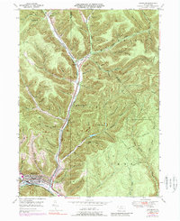
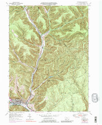
1948 Map of Emporium
USGS Topo · Published 1989About this map
Emporium serves as the industrial and transport hub at the southern edge of this mid-century survey, situated at the confluence of West Branch Sinnemahoning Creek and Sinnemahoning Creek. The landscape is defined by the deep valleys of the Portage and Lumber districts, where the Penn Central railroad follows the narrow shelf of the creek north toward Sizerville. This rail-oriented settlement pattern is flanked by high summits like Mt Kinley and Parker Hill, with many tributary hollows such as Lucore Hollow and Rednor Hollow showing the rugged topography that shaped local logging and infrastructure.
Find a feature on this map
48 named features on this map. Tap any name to fly to it.
Don’t see what you’re looking for? This feature index may not catch every label — zoom into the map to look around manually.
Map Details
Editions of this 1948 Emporium Map
6 editions found

Other maps of this area

1941 · Benezette
USGS Topo · 1:62,500

1943 · Benezette
USGS Topo · 1:62,500

1945 · Driftwood
USGS Topo · 1:48,000

1945 · First Fork
USGS Topo · 1:24,000

1945 · Cameron
USGS Topo · 1:24,000

1947 · Cameron
USGS Topo · 1:24,000

1947 · First Fork
USGS Topo · 1:24,000

1948 · Crosby
USGS Topo · 1:62,500

1948 · Emporium
USGS Topo · 1:62,500

1948 · Keating Summit
USGS Topo · 1:24,000