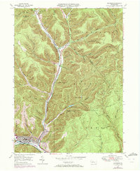
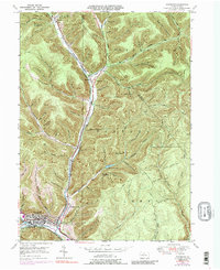
1948 Map of Emporium
USGS Topo · Published 1972About this map
Emporium serves as the industrial and civic anchor of this Cameron County landscape, situated at the confluence of several mountain hollows and the West Branch of the Sinnemahoning Creek. The town is depicted with its grid of streets, City Park, and the Penn Central rail line cutting through the valley floor. To the north, the terrain transitions into the heavily dissected uplands of Portage and Lumber townships, where a network of family-named hollows like Williams Hol and Nady Hol suggests a legacy of homesteading and resource extraction. The map captures an era of conservation and recreation, evidenced by the development of Sizerville Park and an extensive network of named forest paths, including the McDowell Trail and the Switchback Trail. Significant water infrastructure is visible at the Salt Run Reservoir and Upper Reservoir, which supported the growing needs of the valley's population and industry during the mid-20th century.
Find a feature on this map
82 named features on this map. Tap any name to fly to it.
Don’t see what you’re looking for? This feature index may not catch every label — zoom into the map to look around manually.
Map Details
Editions of this 1948 Emporium Map
6 editions found

Other maps of this area

1941 · Benezette
USGS Topo · 1:62,500

1943 · Benezette
USGS Topo · 1:62,500

1945 · Driftwood
USGS Topo · 1:48,000

1945 · First Fork
USGS Topo · 1:24,000

1945 · Cameron
USGS Topo · 1:24,000

1947 · Cameron
USGS Topo · 1:24,000

1947 · First Fork
USGS Topo · 1:24,000

1948 · Crosby
USGS Topo · 1:62,500

1948 · Emporium
USGS Topo · 1:62,500

1948 · Keating Summit
USGS Topo · 1:24,000