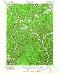
1948 Map of Emporium
USGS Topo · Published 1968About this map
Emporium sits at the confluence of West Creek and Sinnemahoning Creek in this mid-century topographic record of Cameron County. The landscape is defined by the deep valleys of Portage Creek and the First Fork, where the Pennsylvania RR winds through tight mountain passes. Settlements like Keating Summit and Austin are connected by early motor routes such as Hunting Shanty State Road and Shawmut State Road, reflecting a transition from timber-driven economies to recreational and infrastructure development. Local heritage is visible in the distribution of family and community landmarks, including Sizerville Park and the isolated Reesville Sch. The presence of the Fox Mountain Fire Tower and multiple reservoirs, such as the Upper Reservoir, points to a landscape managed for both resource protection and public utility during the post-war era.
Find a feature on this map
111 named features on this map. Tap any name to fly to it.
Don’t see what you’re looking for? This feature index may not catch every label — zoom into the map to look around manually.
Map Details
Editions of this 1948 Emporium Map

Other maps of this area

1932 · Genesee
USGS Topo · 1:62,500

1933 · Smethport
USGS Topo · 1:62,500

1934 · Coudersport
USGS Topo · 1:48,000

1937 · Genesee
USGS Topo · 1:62,500

1937 · Smethport
USGS Topo · 1:62,500

1938 · Coudersport
USGS Topo · 1:62,500

1941 · Benezette
USGS Topo · 1:62,500

1943 · Benezette
USGS Topo · 1:62,500

1945 · Driftwood
USGS Topo · 1:48,000

1945 · First Fork
USGS Topo · 1:24,000