
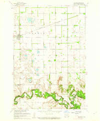
1960 Map of Enderlin South
USGS Topo · Published 1962About this map
The Northern Pacific railroad cuts a diagonal line across this Ransom County landscape, connecting the town of Enderlin to the broader regional economy. Situated at the junction of the Maple River and its South Branch, the area shows a clear pattern of prairie settlement organized into townships like Liberty, Greene, Casey, and Shenford. The map reveals a community deeply rooted in its local institutions, with numerous rural burial sites including St Marys Cem, St Olaf Cem, and Immanuel Cem serving the surrounding farmsteads.
Find a feature on this map
19 named features on this map. Tap any name to fly to it.
Don’t see what you’re looking for? This feature index may not catch every label — zoom into the map to look around manually.
Map Details
Editions of this 1960 Enderlin South Map
This is the sole edition of this map. No revisions or reprints were ever made.
Other maps of this area

1895 · Casselton
USGS Topo · 1:125,000

1897 · Tower
USGS Topo · 1:125,000

1897 · Casselton
USGS Topo · 1:125,000

1907 · Wyndmere
USGS Topo · 1:125,000

1953 · Fargo
USGS Topo · 1:250,000

1956 · Fargo
USGS Topo · 1:250,000

1960 · Lisbon NE
USGS Topo · 1:24,000

1960 · Venlo
USGS Topo · 1:24,000
1960 · Sheldon
USGS Topo · 1:24,000

1961 · Sheldon NW
USGS Topo · 1:24,000