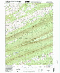
1995 Map of Enders
USGS Topo · Published 1999About this map
Peters Mountain, Stony Mountain, and Third Mountain form the rhythmic, ridged spine of this Dauphin County landscape. This mid-1990s record of the area reveals a geography defined by its deep, parallel valleys and the narrow watercourses of Powell Creek, Clark Creek, and Stony Creek. The map documents numerous rural landmarks that suggest a long-standing local history, from Victoria Furnace and Ellendale Forge to small educational and religious hubs like the Enders-Fisherville Sch and St James Ch. Much of the central terrain is preserved as State Game Lands No 211, while the Appalachian Trail and Aqueduct traverse the high ground. The southern boundary reaches into West Hanover, passing through Ritzie Village and the community of Piketown.
Find a feature on this map
52 named features on this map. Tap any name to fly to it.
Don’t see what you’re looking for? This feature index may not catch every label — zoom into the map to look around manually.
Map Details
Editions of this 1995 Enders Map
This is the sole edition of this map. No revisions or reprints were ever made.
Other maps of this area

1892 · Lykens
USGS Topo · 1:62,500

1892 · Hummelstown
USGS Topo · 1:62,500

1892 · Harrisburg
USGS Topo · 1:62,500

1893 · Lykens
USGS Topo · 1:62,500

1893 · Millersburg
USGS Topo · 1:62,500

1899 · Harrisburg
USGS Topo · 1:62,500

1924 · Hummelstown
USGS Topo · 1:62,500

1924 · Harrisburg
USGS Topo · 1:62,500

1943 · Millersburg
USGS Topo · 1:62,500

1943 · Lykens
USGS Topo · 1:62,500
Featured Places
- Jackson Township, PA
- Jefferson Township, PA
- West Hanover Township, PA
- Rush Township, PA
- Middle Paxton Township, PA