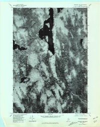
1978 Map of Endless Lake
USGS Topo · Published 1981About this map
Endless Lake dominates this late-1970s orthophotograph, stretching across the north-central portion of the quadrangle. The imagery, captured during an October aerial survey, provides a clear view of the complex shoreline and surrounding timberland within this portion of the Maine woods. To the west, the eastern edge of Seboeis Lake is visible, while Turtle Pond occupies the southwestern quadrant. The hydrological network is defined by Roaring Brook and the West Branch Seboeis Stream, which flow through a landscape showing the distinct textural patterns of forest management and natural drainage. This orthophotoquad serves as a precise record of the shoreline and land cover before later development or natural shifts in the Maine wilderness, emphasizing the area's interior water bodies over human settlement.
Find a feature on this map
5 named features on this map. Tap any name to fly to it.
Don’t see what you’re looking for? This feature index may not catch every label — zoom into the map to look around manually.
Map Details
Editions of this 1978 Endless Lake Map
This is the sole edition of this map. No revisions or reprints were ever made.
Other maps of this area

1942 · Lincoln
USGS Topo · 1:62,500

1947 · Schoodic
USGS Topo · 1:62,500

1949 · Schoodic
USGS Topo · 1:62,500

1951 · Norcross
USGS Topo · 1:62,500

1951 · Millinocket
USGS Topo · 1:62,500

1954 · Millinocket
USGS Topo · 1:250,000

1957 · Lincoln
USGS Topo · 1:62,500

1958 · Millinocket
USGS Topo · 1:250,000

1960 · Millinocket
USGS Topo · 1:250,000

1975 · Millinocket SW
USGS Topo · 1:24,000
Featured Places
- Lake View Plantation, ME
- Seboeis Plantation, ME
- T4 R9 NWP, ME
- Cedar Lake Township, ME
- Penobscot County, ME