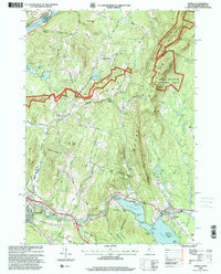
1996 Map of Enfield
USGS Topo · Published 2001About this map
The Connecticut River forms the western boundary of this New Hampshire landscape, where the terrain rises from the riverbanks toward the peaks of the White Mountain National Forest. Central to the region's geography is the massive Mascoma Lake, which features several named islands including North Island and Relham Island. The cultural history of the area is evident in the presence of Enfield and landmarks such as the Shaker Bridge and Shaker Hill, reflecting the legacy of the Shaker community on the lake's southern shores.
Find a feature on this map
72 named features on this map. Tap any name to fly to it.
Don’t see what you’re looking for? This feature index may not catch every label — zoom into the map to look around manually.
Map Details
Editions of this 1996 Enfield Map
This is the sole edition of this map. No revisions or reprints were ever made.
Other maps of this area

1896 · Strafford
USGS Topo · 1:62,500

1906 · Hanover
USGS Topo · 1:62,500

1908 · Hanover
USGS Topo · 1:62,500

1927 · Mascoma
USGS Topo · 1:62,500

1931 · Mt. Cube
USGS Topo · 1:62,500

1932 · Mascoma
USGS Topo · 1:62,500

1933 · Mt. Cube
USGS Topo · 1:62,500

1944 · Strafford
USGS Topo · 1:62,500

1950 · Glens Falls
USGS Topo · 1:250,000

1956 · Glens Falls
USGS Topo · 1:250,000