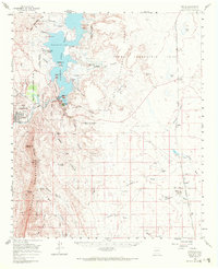
1959 Map of Engle
USGS Topo · Published 1972About this map
Elephant Butte Reservoir and the Rio Grande anchor this mid-century survey of the New Mexico landscape, dominated by the Fra Cristobal Range and the Caballo Mountains. The map documents a critical period of infrastructure and memory, capturing the Elephant Butte Dam and the historic site of Fort McRae, which sits near the shoreline. To the east, the Jornada del Muerto basin is traversed by the Atchison Topeka and Santa Fe railroad, which connects the small settlements of Engle and Cutter.
Find a feature on this map
59 named features on this map. Tap any name to fly to it.
Don’t see what you’re looking for? This feature index may not catch every label — zoom into the map to look around manually.
Map Details
Editions of this 1959 Engle Map
2 editions found

Other maps of this area

1916 · Tonuco
USGS Topo · 1:125,000

1916 · Salinas Peak
USGS Topo · 1:125,000

1932 · Tonuco
USGS Topo · 1:125,000

1948 · Sowell
USGS Topo · 1:62,500

1948 · Chicken Well
USGS Topo · 1:62,500

1948 · Malpais Well
USGS Topo · 1:62,500

1954 · Tularosa
USGS Topo · 1:250,000

1955 · Las Cruces
USGS Topo · 1:250,000

1958 · Las Cruces
USGS Topo · 1:250,000

1958 · Tularosa
USGS Topo · 1:250,000