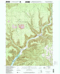
1994 Map of English Center
USGS Topo · Published 1999About this map
English Center sits at the confluence of several mountain waterways, where Little Pine Creek meets Texas Creek and English Run. This 1994 photoinspection of the Lycoming County highlands reveals a landscape dominated by public conservation and extractive industry. Massive tracts of State Game Lands No 75 and the Tiadaghton State Forest wrap around the steep drainages of Lick Run and Otter Run, while numerous Strip Mines on the high ridges of Brown Ridge and Chestnut Ridge indicate the area's continued reliance on coal resources. Genealogy researchers can locate remote burial grounds including Carsontown Cem and Dowling Hill Cem, which remain as markers of small settlements like Carsontown and Brookside. The map also details the southern extent of Little Pine Park, noting areas subject to inundation by the Little Pine Dam.
Find a feature on this map
74 named features on this map. Tap any name to fly to it.
Don’t see what you’re looking for? This feature index may not catch every label — zoom into the map to look around manually.
Map Details
Editions of this 1994 English Center Map
This is the sole edition of this map. No revisions or reprints were ever made.
Other maps of this area

1921 · Trout Run
USGS Topo · 1:62,500

1923 · Trout Run
USGS Topo · 1:62,500

1925 · Blossburg
USGS Topo · 1:62,500

1927 · Blossburg
USGS Topo · 1:62,500

1935 · Waterville
USGS Topo · 1:24,000

1937 · Waterville
USGS Topo · 1:48,000

1943 · Waterville
USGS Topo · 1:62,500

1944 · Blossburg
USGS Topo · 1:62,500

1944 · Trout Run
USGS Topo · 1:62,500

1946 · Antrim
USGS Topo · 1:62,500
Featured Places
- Brookside, Cogan House Township
- Cogan House Township, PA
- Carsontown, Pine Township
- Brown Township, PA
- Pine Township, PA